Caisteal nan Coin Duibh – ‘the Castle of the Black Dogs’
February 11, 2018/
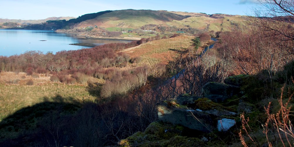
Ten minutes’ walk from the hazel grove (described in my previous post) brought us alongside a field of rough grass and bracken that rises quite steeply to a natural rocky outcrop. Built into the top of this outcrop is a ruined hillfort known, according to a signpost, as ‘Caisteal nan Coin Duibh’. I was delighted to discover that this means ‘the fort or castle of the black dogs’. (Those old people knew how to name places, that’s for sure! How can you see that and pass it by?)
The drop on the north-west facing side is pretty sheer, so we crossed into the field with the intention of going round the back and finding a more welcoming route. It was only a short climb but still not the easiest, as the ground is littered with massive boulders half-smothered by grass, bracken and thick ropes of bramble: you can easily plunge your foot into an unseen hole and twist your ankle.
I stopped half-way up to admire a miniature rock-garden of emerald moss, and reflected on the story I’d read about this place. According to Fingalian legend, two mighty dogs once fought near here, on a natural platform called Lergychoniemor (from Learg-a-choinnimh, or plateau of the meeting). One of the dogs was Bran, beloved hound of Fionn mac Cumhaill; the other, named Foir, belonged to the Prince of Innse Orc (Orkney). Foir was killed in the fight, and was given an honourable burial under a nearby standing stone.*
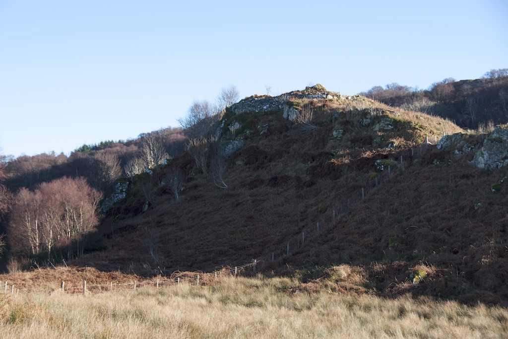
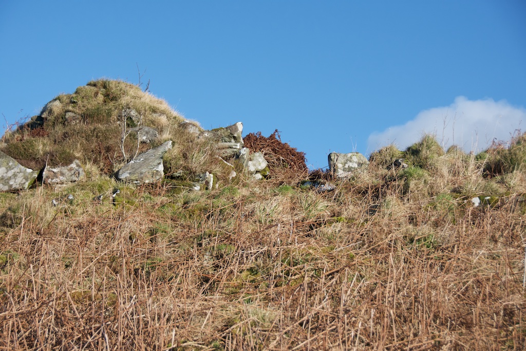
Approaching from the south-west brought us in line with what I guessed must have been an entrance – now just a gap in the few courses of stone that remain. Standing rather precariously on the low wall, you can just about make out that the structure was once circular. A few small mountain ash trees are making the best of it, their roots holding fast to the walls while their stunted branches stand in defiance of the wind.
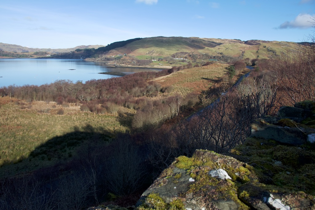
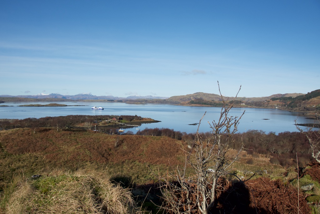
I picked my way around to the side with the sheer drop and perched on a lichen-covered boulder to admire the view. It was spectacular – a perfect blue sea melting away into the distance, with boats lazily making their way to and fro. The hills of Morvern were lurking to the far north-west, with the snowy peaks of Mull more directly west; moving round, you could see the lumpy shape of Scarba and the distant Paps of Jura with the Corryvreckan whirlpool – or at least the stretch of water that holds it – visible in between. Robins were singing, and from far beneath the walls I could hear the barking of dogs. Dogs? Yes, really. Nothing supernatural: I could actually see them, tiny specks but dogs nonetheless, running around on the shore a couple of hundred feet below.
“In the interior there are the remains of at least two animal-pens and a modern rectilinear cairn.” Canmore, from a survey in 1978
Looking roughly north-east, across the interior to the hills beyond
Surveyors reckon that the walls were once between 10 and 12 feet thick, and at least one visitor detected traces of a gallery in the north-west face. I’m guessing that, at the time of these visits, the site was a little less overgrown than it is now. A deep layer of dead bracken masks the randomly fallen stones. It’s difficult to walk across it, and impossible to identify any features. A faint path – possibly a deer track – has been worn through the bracken. Whatever it was once used for, this place is now thrown open to the winds, and they tear across the Firth of Lorn with some force. It’s not a place you’d go to for shelter; you’d take yourself down into the woods, because the wind in the trees is not quite as unsettling as the wind howling through the crevices of a stone wall, dogs or no dogs.
*The stone that is said to mark the dog’s grave is no longer standing, and surveyors are now doubtful of its identity.
Half a mussel shell, on a hilltop? Seagulls are the likely culprit, dropping them onto the stones to smash them open.
Brochs and duns
Both words signify a stone-built, roughly circular structure, probably dating from the Iron Age. Brochs tend to be scattered up in the north of Scotland and its islands – Mousa Broch on Shetland is the best-preserved example. By contrast, if you open a map of western Scotland anywhere from Argyll upwards, you’ll come across the word ‘dun’ in several places, usually on a low hill or vantage point. In most cases there’s probably little left of it, other than a pile of stones.
It can be confusing to try and understand the difference between brochs and duns, especially since a lot of brochs have a proper name that includes ‘dun’ – for example Dun Carloway on the Isle of Lewis (above) and Dun Telve and Dun Troddan at Glenelg.
Dun Beag, Isle of Skye
Is there any difference at all? Some sources state simply that brochs were known as duns in the west of Scotland. Others clarify by explaining that brochs were designed to be an expression of power, and were wider and taller than duns, double-walled with a stone staircase inside the cavity, and containing several floors. But then there are such things as galleried duns, and duns with enclosures, and the definitions become a bit blurry.
The truth is that we really don’t know enough about why they were built, and who actually used them. One theory, which interests me, is that duns could have been signalling places, to warn people up and down the coast of invaders coming across the sea.
Well you do have a great deal to explore in that part of Argyll (even though you are already familiar with much of it). So look forward to more discoveries to come. Thanks for the open views, I can now place where you are in your new home….nice indeed.
So stunning. I try to imagine the daily lives of those who used it and looked out in all weathers and also heard robins singing (maybe), but saw different boats! Thanks for the photos & the words.
Beautiful photos, Jo. I can understand you being lured by the name of the castle. Do you think in those long gone days Argyll was a more highly populated area than it is now? There seem to be a lot of these small settlements dotted about, but does anyone know how many people a place like the castle of the black dogs would be likely to house?
Thank you, Lorna! Yes, how could you not be intrigued by such a place?! From what I’ve read, I think it’s very difficult for historians to say how many people lived in Argyll during that time, or even how many people would have inhabited a dun or a broch. When I was researching a similar site in Knoydart, sources suggested that the broch was not the only habitation of that time on that coast, but that it was built to impress, perhaps used only by a select few, and that the more humble dwellings were built of materials such as wood and thatch, which of course have perished over time. So we’re back the scenario of interpreting history through what has survived. The overriding sense I get is that there was a strong connection with the sea, because that’s where trade and news, settlers and invasions mostly came from. I’m tempted to think these places were a refuge as well as a vantage point. But that is purely speculation!
Hi Jo. I think you live in the most historically romantic area in Britain and incredible how so many old legends have been carried down the centuries and you’re right in the middle of them with the rare skill of reciting them for us along with great photographs.
Have you ever managed to reach the Treshnish Isles off Mull and see their castles?
There’s very little written about them and yet they were imporatnt enough to be attacked by Oliver Cromwell’s ships. Possibly Viking in origin It is believed a lot of old books and manuscripts stored there from Iona were burned by Cromwell’s men….’relics of idolatry’.
Re the galleys at Kilchattan.
In Denis Rixon’s definitive book ‘The West Highland Galley’ he mentions the problem of dating them. They don’t show either a steering board or stern rudder . Rudders as we know them started appearing on grave slabs towards the end of the 13th century.
Hi Bob, yes – I know, we’re just so lucky! I often think that myself – I’m in the midst of a landscape of legends, and I love it so much. It’s funny that you should mention the castles on the Treshnish Isles. No, I haven’t been there, and I only read about Cairnburgh Castle quite recently and was astonished that such a place existed out there. I would love to go and explore it! It would be fabulous to take a boat trip out there. I didn’t know that some of the old Iona records were thought to have been stored there. Do you have any recommended reading/sources? Regarding the Kilchattan galleys, I don’t have Denis Rixson’s book but I understand what you’re saying. From the engravings, it’s pretty impossible to tell what kind of vessels they are, anyway, so it’s all speculation, fired by eager imagination! I get the impression that Marion Campbell was a meticulous historian but she too wanted to believe the folklore. I wonder if the remains of any galleys/birlinns have ever been found and excavated. Are you aware of any?
Have you seen this Jo. https://www.youtube.com/watch?v=kUr95Ei0A30
Now somewhere I have seen an updated report on this site where they did in fact find a part of a galley / longship which supported a thwart if I recall. Quite incredible considering the preservative qualities of peat that no birlinn parts have been found, but then again there are several times where the Central Scottish Governments of the times ordered their total destruction for military logistical reasons.
That’s very interesting, thank you! I do remember that being discovered, now you mention it. An intact Viking ship burial was found recently in Ardnamurchan, but I don’t know what kind of ship it was.
Thanks, Bob – I don’t think I’d ever read about that! What a spectacular find. Looking at Canmore, it says that the finds were presented to the Royal Scottish Museum so I guess they might now be in the National Museum of Scotland: https://canmore.org.uk/site/38173/colonsay-kiloran-bay

 Ten minutes’ walk from the hazel grove (described in my previous post) brought us alongside a field of rough grass and bracken that rises quite steeply to a natural rocky outcrop. Built into the top of this outcrop is a ruined hillfort known, according to a signpost, as ‘Caisteal nan Coin Duibh’. I was delighted to discover that this means ‘the fort or castle of the black dogs’. (Those old people knew how to name places, that’s for sure! How can you see that and pass it by?)
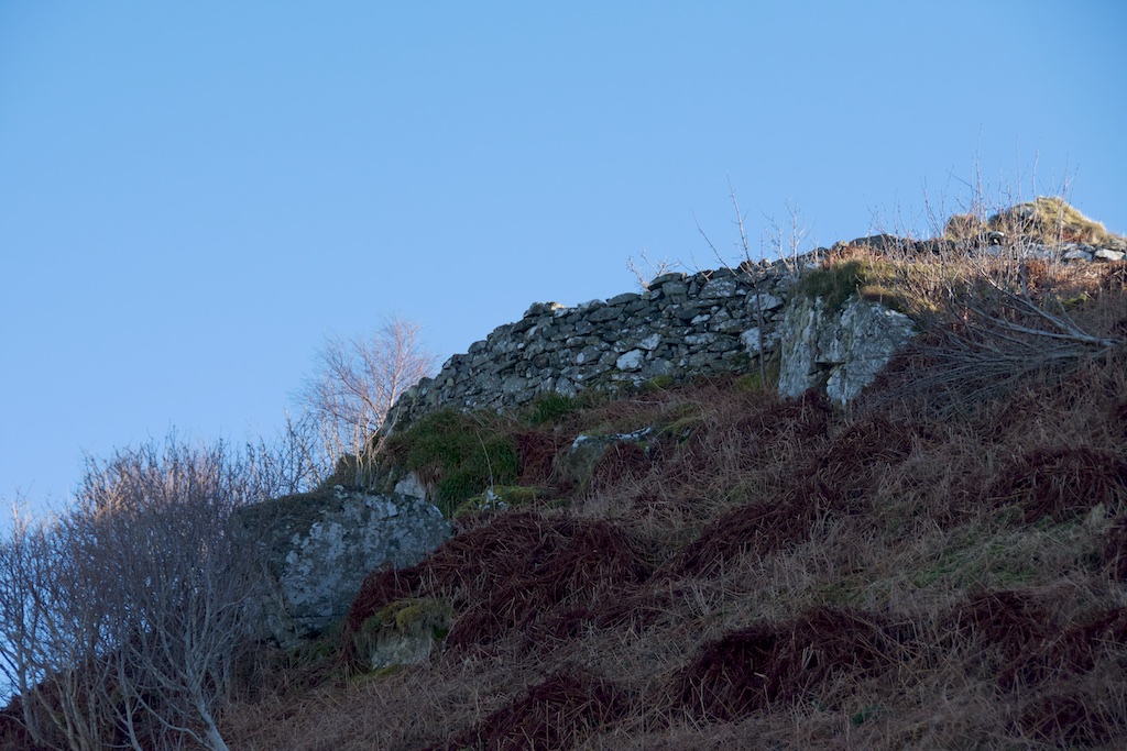 The drop on the north-west facing side is pretty sheer, so we crossed into the field with the intention of going round the back and finding a more welcoming route. It was only a short climb but still not the easiest, as the ground is littered with massive boulders half-smothered by grass, bracken and thick ropes of bramble: you can easily plunge your foot into an unseen hole and twist your ankle.
 I stopped half-way up to admire a miniature rock-garden of emerald moss, and reflected on the story I’d read about this place. According to Fingalian legend, two mighty dogs once fought near here, on a natural platform called Lergychoniemor (from Learg-a-choinnimh, or plateau of the meeting). One of the dogs was Bran, beloved hound of Fionn mac Cumhaill; the other, named Foir, belonged to the Prince of Innse Orc (Orkney). Foir was killed in the fight, and was given an honourable burial under a nearby standing stone.*
 Approaching from the south-west brought us in line with what I guessed must have been an entrance – now just a gap in the few courses of stone that remain. Standing rather precariously on the low wall, you can just about make out that the structure was once circular. A few small mountain ash trees are making the best of it, their roots holding fast to the walls while their stunted branches stand in defiance of the wind.
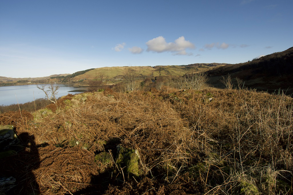
 I picked my way around to the side with the sheer drop and perched on a lichen-covered boulder to admire the view. It was spectacular – a perfect blue sea melting away into the distance, with boats lazily making their way to and fro. The hills of Morvern were lurking to the far north-west, with the snowy peaks of Mull more directly west; moving round, you could see the lumpy shape of Scarba and the distant Paps of Jura with the Corryvreckan whirlpool – or at least the stretch of water that holds it – visible in between. Robins were singing, and from far beneath the walls I could hear the barking of dogs. Dogs? Yes, really. Nothing supernatural: I could actually see them, tiny specks but dogs nonetheless, running around on the shore a couple of hundred feet below.
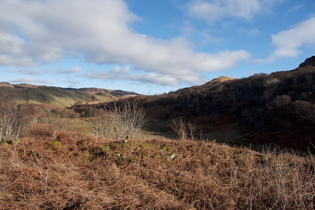 Looking roughly north-east, across the interior to the hills beyond
 Half a mussel shell, on a hilltop? Seagulls are the likely culprit, dropping them onto the stones to smash them open.
It can be confusing to try and understand the difference between brochs and duns, especially since a lot of brochs have a proper name that includes ‘dun’ – for example Dun Carloway on the Isle of Lewis (above) and Dun Telve and Dun Troddan at Glenelg.


18 Comments
Stravaiging around Scotland
Interestingly in Glen Lyon in Perthshire there’s a similarly-named Caisteal Cona Bhacain (http://www.stravaiging.com/history/ancient/site/caisteal-cona-bhacain) associated with Fingal complete with a mini standing stone nearby (Cona Bhacain http://www.stravaiging.com/history/ancient/site/cona-bhacain) to which he is supposed to have tied Bran. I wonder if these are two separate legends or have the same origin.
davidoakesimages
Thanks for the links…… and a unique form of contraception !! Next time I am in Glen Lyon I will keep a more watchful eye open for Cona-Bhacain
Jo Woolf
That’s very interesting! I’m sure the legends must be the same, or at least the same characters. Will check the links, thank you! Love Glen Lyon.
Stravaiging around Scotland
It’s definitely the same characters, I’m just curious if it’s the same story transplanted to a different area, or different stories with similarities.
montucky
The history there is fascinating and the scenery is beautiful. You could let your imagination run free, standing on those ruins.
Jo Woolf
Yes, it’s a beautiful and quiet part of the world. So much ancient history here – you really can let your imagination run riot!
davidoakesimages
Well you do have a great deal to explore in that part of Argyll (even though you are already familiar with much of it). So look forward to more discoveries to come. Thanks for the open views, I can now place where you are in your new home….nice indeed.
Edith Douglas
So stunning. I try to imagine the daily lives of those who used it and looked out in all weathers and also heard robins singing (maybe), but saw different boats! Thanks for the photos & the words.
Jo Woolf
I know Edith, wouldn’t it be fascinating to glimpse that time! Really glad you enjoyed it, and thank you.
Lorna
Beautiful photos, Jo. I can understand you being lured by the name of the castle. Do you think in those long gone days Argyll was a more highly populated area than it is now? There seem to be a lot of these small settlements dotted about, but does anyone know how many people a place like the castle of the black dogs would be likely to house?
Jo Woolf
Thank you, Lorna! Yes, how could you not be intrigued by such a place?! From what I’ve read, I think it’s very difficult for historians to say how many people lived in Argyll during that time, or even how many people would have inhabited a dun or a broch. When I was researching a similar site in Knoydart, sources suggested that the broch was not the only habitation of that time on that coast, but that it was built to impress, perhaps used only by a select few, and that the more humble dwellings were built of materials such as wood and thatch, which of course have perished over time. So we’re back the scenario of interpreting history through what has survived. The overriding sense I get is that there was a strong connection with the sea, because that’s where trade and news, settlers and invasions mostly came from. I’m tempted to think these places were a refuge as well as a vantage point. But that is purely speculation!
Bob Hay
Hi Jo. I think you live in the most historically romantic area in Britain and incredible how so many old legends have been carried down the centuries and you’re right in the middle of them with the rare skill of reciting them for us along with great photographs.
Have you ever managed to reach the Treshnish Isles off Mull and see their castles?
There’s very little written about them and yet they were imporatnt enough to be attacked by Oliver Cromwell’s ships. Possibly Viking in origin It is believed a lot of old books and manuscripts stored there from Iona were burned by Cromwell’s men….’relics of idolatry’.
Re the galleys at Kilchattan.
In Denis Rixon’s definitive book ‘The West Highland Galley’ he mentions the problem of dating them. They don’t show either a steering board or stern rudder . Rudders as we know them started appearing on grave slabs towards the end of the 13th century.
Jo Woolf
Hi Bob, yes – I know, we’re just so lucky! I often think that myself – I’m in the midst of a landscape of legends, and I love it so much. It’s funny that you should mention the castles on the Treshnish Isles. No, I haven’t been there, and I only read about Cairnburgh Castle quite recently and was astonished that such a place existed out there. I would love to go and explore it! It would be fabulous to take a boat trip out there. I didn’t know that some of the old Iona records were thought to have been stored there. Do you have any recommended reading/sources? Regarding the Kilchattan galleys, I don’t have Denis Rixson’s book but I understand what you’re saying. From the engravings, it’s pretty impossible to tell what kind of vessels they are, anyway, so it’s all speculation, fired by eager imagination! I get the impression that Marion Campbell was a meticulous historian but she too wanted to believe the folklore. I wonder if the remains of any galleys/birlinns have ever been found and excavated. Are you aware of any?
Bob Hay
Have you seen this Jo. https://www.youtube.com/watch?v=kUr95Ei0A30
Now somewhere I have seen an updated report on this site where they did in fact find a part of a galley / longship which supported a thwart if I recall. Quite incredible considering the preservative qualities of peat that no birlinn parts have been found, but then again there are several times where the Central Scottish Governments of the times ordered their total destruction for military logistical reasons.
Jo Woolf
That’s very interesting, thank you! I do remember that being discovered, now you mention it. An intact Viking ship burial was found recently in Ardnamurchan, but I don’t know what kind of ship it was.
Bob Hay.
Here’s a report of a 30 foot long boat type burial Jo.
https://www.vikingeskibsmuseet.dk/en/professions/education/the-viking-age-geography/the-vikings-in-the-west/scotland/colonsay-viking-graves
Wonder where the contents are.
Jo Woolf
Thanks, Bob – I don’t think I’d ever read about that! What a spectacular find. Looking at Canmore, it says that the finds were presented to the Royal Scottish Museum so I guess they might now be in the National Museum of Scotland: https://canmore.org.uk/site/38173/colonsay-kiloran-bay
Bob Hay.
That’s where they are Jo. The NMS.